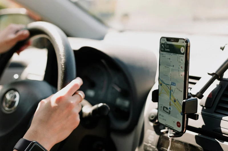

Have you ever looked at your car’s dashboard and wondered if youre pressing the gas too hard? With Android Auto and Google Maps, you have a digital co-pilot that not only guides you along the best route but can also show your current speed on-screen and alert you if you exceed the roads limit. This feature, discreet yet powerful, turns your dash into a more useful control center, almost like a digital HUD, and helps you drive with greater calm, safety, and precision.
The key is to enable Google Maps built-in speedometer, a tool that compares your speed to the posted limit and issues a visual alert when you go over. Keep in mind there can be a small difference compared to the cars gauge, but using both as references gives you a more complete picture of whats actually happening on the road.
How to enable the speedometer in Google Maps
Getting it running is very easy and will only take a minute. Just open Google Maps on your phone, tap your profile picture in the top-right corner and go into Settings. Then go to Navigation and, under Driving options, turn on the Speedometer option. From that moment on, Google Maps will show the speed on both the smartphone and the Android Auto screen when you start a driving route.
Once active, youll see the km/h in the lower-left corner, always visible during navigation, so you dont have to shift your gaze between different elements. If you exceed the road limit, the indicator turns red—a clear visual cue that its time to ease off the accelerator. Its a simple, straightforward aid that, like any good gadget, runs in the background without demanding attention.
Although its performance is excellent, its good practice to also check the vehicles speedometer, especially if you suspect any discrepancies. In fact, combining both readings provides an extra layer of reassurance and reduces the chance of oversights, something any driver appreciates on long trips or in urban areas with changing limits.

Why its worth using
Google Maps speedometer provides clear benefits from the first kilometer. For starters, it shows your speed continuously in the same place where you follow the route, which reduces the effort of shifting your gaze between multiple indicators and avoids unnecessary distractions. Also, by comparing your speed with the road limit and warning you when you exceed it, it helps you maintain safer driving and avoid speeding fines.
It also serves as a backup when the cars instrument panel has calibration issues or malfunctions, because having two sources of information lets you spot inconsistencies. In practice, its like adding a virtual tachometer to your navigator: everything in a single interface, optimized for the road, and powered by GPS measurements—an old favorite of any tech enthusiast who gets excited by GNSS precision and real-time data.
The usefulness isnt just theoretical: Spains Directorate-General for Traffic (Direccin General de Trfico) highlights that speed remains one of the main causes of accidents, with 211 fatal accidents in 2023 related to driving above limits. In that context, a simple visual cue reminding you when youre crossing the red line can make a difference. It doesnt replace responsible driving, but it fits as an ideal complement alongside other car aids—just as cruise control helps you keep the pace on long stretches.
Why do the speeds sometimes not match?
If you notice Google Maps km/h not mirroring the cars, dont be alarmed: small differences are normal. The reason is how each system measures speed. The cars speedometer is based on wheel rotation, a method sensitive to factors like tire wear or pressure; therefore, manufacturers usually apply a margin that makes the cars gauge tend to show a figure slightly higher than the real one, but never lower.
Google Maps, on the other hand, calculates speed from the devices GPS, estimating distance traveled over a given time period. This approach tends to be closer to the actual speed, although it can also show minor variations due to signal quality or the environment. In practice, the important thing is to understand that both readings are valid within their context and that combining them gives you a more complete picture of your driving.
The conclusion is simple: enable the Google Maps speedometer, pay attention to the red warning when appropriate, and use that information to modulate your driving. With everything visible on the Android Auto screen, youll have fewer distractions and more control, which is exactly what those of us who love technology well-applied to driving are looking for.
